
Quick answer
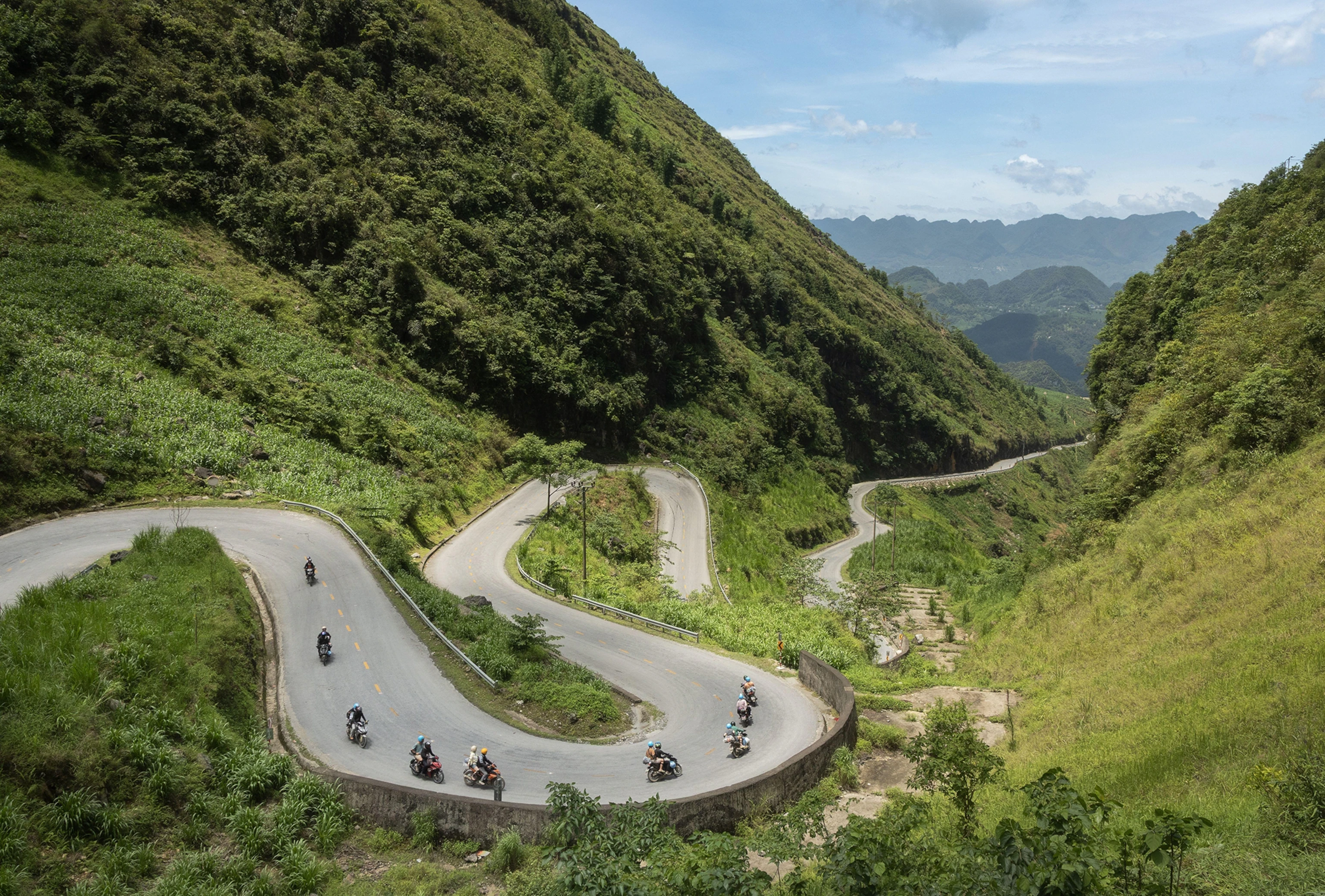
The optimal window for the Ha Giang Loop runs from September through November and March through May, when roads are dry, skies are clear, and temperatures remain manageable. October stands out as the single best month — buckwheat flowers blanket the highlands in pink and white, harvest season brings terraced fields to life, and the monsoon has fully cleared. December through February brings sharp cold and occasional frost above 1,500 meters, while June through August sees heavy rains that trigger landslides and reduce visibility.
Northern Vietnam's weather operates on a monsoon cycle that governs every aspect of the loop. The region sits at latitudes where subtropical and temperate zones collide, creating microclimates that shift with altitude. A morning departure from Ha Giang town at 25°C can end at Dong Van plateau in single digits by nightfall, and a dry valley road can meet rain-slicked switchbacks two passes later. September marks the monsoon's retreat. Roads that spent July and August under intermittent downpours begin to dry, and the risk of landslides drops sharply. By October, the buckwheat harvest transforms the highlands into a patchwork of color — terraced rice fields turn golden, and the ethnic minority communities celebrate the end of the growing season. Visibility peaks during these months, with clear skies offering unobstructed views of the karst formations that define the Dong Van plateau. November holds the weather but loses the buckwheat; temperatures begin their slide toward winter. The spring window — March through May — mirrors autumn's conditions but reverses the agricultural calendar. Fields lie fallow or freshly planted, and the landscape skews green rather than gold. April brings the warmest days without triggering the monsoon, making it the preferred month for riders seeking moderate temperatures. By late May, afternoon thunderstorms begin to appear, signaling the monsoon's approach. Winter months demand preparation. December through February see temperatures fall below 5°C at higher elevations, and frost is common on the Dong Van plateau. Roads remain passable, but the cold deters casual riders, and many guesthouses in remote villages reduce their hours or close entirely. The summer monsoon — June through August — presents the opposite challenge. Daily rainfall totals can exceed 200mm during peak events, and the combination of steep grades and saturated soil makes landslides a persistent risk. Riders who attempt the loop during these months face reduced visibility, slippery roads, and frequent delays. The ha giang loop best time of year ultimately depends on tolerance for cold versus rain, but the shoulder seasons remain the consensus choice. Road safety,景观 visibility, and cultural activity all converge during the autumn and spring windows, leaving little reason to ride outside them unless schedule constraints dictate otherwise.
“A morning departure from Ha Giang town at 25°C can end at Dong Van plateau in single digits by nightfall, and a dry valley road can meet rain-slicked switchbacks two passes later.”
Understanding the Ha Giang Loop Best Time of Year
The period from September to November and March to May offers the most stable conditions for navigating the Ha Giang Loop. These months balance clear visibility with moderate temperatures, ideal for traversing high-altitude mountain passes.
September–November
Moderate to highDry, 15°C–25°C, clear skies. Ideal for viewing terraced rice fields during the harvest season.
March–May
ModerateMild, 18°C–28°C, occasional light rain. Landscapes remain lush and vibrant following the spring bloom.
June–August
HighHot, 25°C–35°C, frequent heavy rain. High precipitation increases the risk of road slips and reduced visibility.
December–February
LowCold, 5°C–15°C, dry and foggy. Temperatures at high elevations often drop significantly, requiring specialized gear.
Verdict: For the best balance of road safety and visibility, plan your trip during the shoulder months of October or April.
Planning Your Ha Giang Loop Best Time of Year Visit Duration
This 3-to-4-day loop suits riders comfortable on mountain roads who can adjust their pace based on weather conditions. The schedule prioritizes safe daylight riding and allows time for photography stops at key viewpoints.
Ha Giang to Quan Ba
Depart Ha Giang town by 08:00, ride 45 km north to Quan Ba with a stop at Heaven's Gate viewpoint. Clear morning light is critical for the Twin Mountain vista; allow 3 hours including photo time.
Quan Ba to Yen Minh
Continue 50 km through terraced valleys to Yen Minh, the midpoint rest town. Arrive by 16:00 to secure lodging; roads narrow significantly after this segment.
Yen Minh to Dong Van
Ride 90 km via the Lung Cu flagpole turnoff, Vietnam's northernmost point. Budget 5 hours for winding ascents; fog often clears by 10:00 in dry season.
Dong Van exploration
Walk the old quarter's stone houses and Hmong market area. The town sits at 1,025 m elevation; evenings drop to single digits even in summer.
Ma Pi Leng Pass traverse
Cross the 20 km pass to Meo Vac, then loop back or continue to Du Gia. This section demands full daylight; start no later than 08:30 and expect 6–7 hours riding.
Return to Ha Giang
Retrace via Du Gia or take the eastern route through Bac Me. Either option covers 140–160 km; plan to finish by 17:00 before mountain roads lose light.
How to Arrive for the Ha Giang Loop Best Time of Year
The Ha Giang Loop is located in Ha Giang Province, Northern Vietnam. Travelers typically arrive from Hanoi or Sapa via road transport to reach the starting point in Ha Giang City.
Hanoi to Ha Giang City via QL2
Sapa to Ha Giang City via QL279
Hanoi to Ha Giang City via CT05 and QL2
Seasonal Festivals During the Ha Giang Loop Best Time of Year
Local cultural events and harvests significantly influence the atmosphere and logistics of the Ha Giang Loop. Planning your visit around these dates can provide deeper insight into regional traditions.
Khau Vai Love Market
This event brings diverse ethnic groups together for cultural exchanges and traditional performances in the mountains. Expect high demand for local accommodations as travelers gather to observe this historic gathering.
Buckwheat Flower Season
The landscape changes as fields bloom with pale pink and white buckwheat flowers. This period attracts many photographers and domestic travelers, so booking logistics in advance is recommended.
Preparation Checklist for the Ha Giang Loop Best Time of Year
Prepare for varying mountain weather and road conditions depending on your chosen season.
-
Bring valid passport or Vietnamese ID — Required for permits and hotel check-ins along the route.
-
Pack layers for temperature swings — Mornings in winter can drop to 5°C, afternoons reach 20°C.
-
Download offline maps before departure — Mobile signal is weak or absent in remote valleys.
-
Check motorcycle rental insurance coverage — Accidents on steep hairpin turns are common in wet season.
-
Carry rain gear if visiting May–September — Afternoon downpours make roads slippery and visibility poor.
-
Book accommodation 2–3 weeks ahead for October — Peak buckwheat flower season fills guesthouses quickly.
-
Confirm road conditions with local agencies — Landslides can close sections after heavy rain.
Access and Operational Hours for the Ha Giang Loop Best Time of Year
The Ha Giang Loop consists of public roads in Ha Giang Province, Northern Vietnam, and is accessible 24 hours a day. Travelers should plan their movement according to daylight hours and safety conditions.
| Monday | 00:00–23:59 | |
|---|---|---|
| Tuesday | 00:00–23:59 | |
| Wednesday | 00:00–23:59 | |
| Thursday | 00:00–23:59 | |
| Friday | 00:00–23:59 | |
| Saturday | 00:00–23:59 | |
| Sunday | 00:00–23:59 |
Budgeting for the Ha Giang Loop Best Time of Year
Access to the public roads comprising the Ha Giang Loop is free of charge. Costs for travelers instead depend on specific permits and entry fees for individual attractions like caves.
A typical traveler pays 0 VND for road access, with costs primarily driven by the mandatory foreigner permit and localized attraction fees.
Check availability
Frequently asked questions about ha giang loop best time of year
Everything you need to know about ha giang loop best time of year